 Lorraine Williamson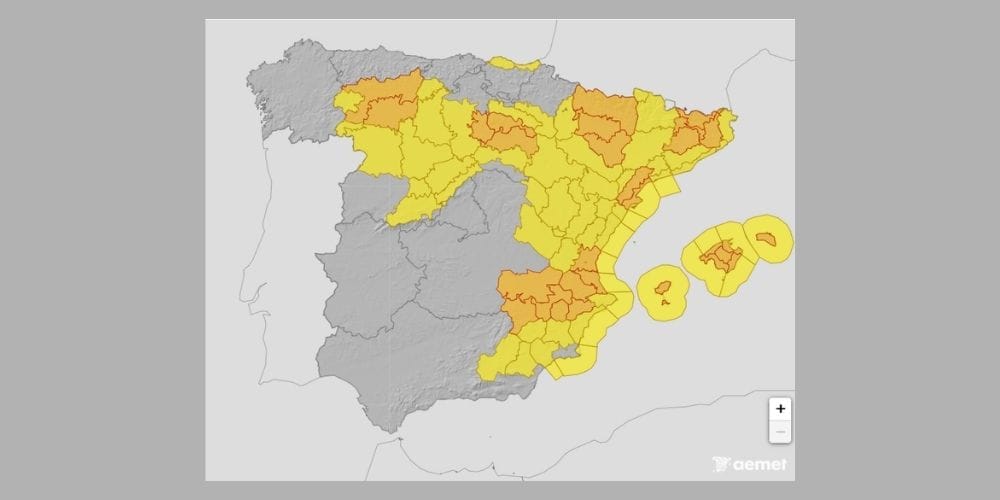
Severe thunderstorms have caused damage in parts of eastern Spain, with the focus now turning to Mallorca, where AEMET has issued orange warnings for torrential rain and potentially damaging winds from Thursday evening.
Spain’s Protección Civil has maintained its weather alert for northern and eastern mainland areas and the Balearic Islands, warning that thunderstorms can be difficult to predict and urging people to follow official updates as conditions develop.
The warning comes as a marked change in the weather spreads across Spain following days of intense summer heat. A change in atmospheric conditions across the Iberian Peninsula is bringing cooler air and greater instability, creating the conditions for heavy showers, thunderstorms, hail, and sudden strong winds.
On Thursday, Protección Civil warned that thunderstorms could be particularly strong in the south-eastern third of mainland Spain, producing downbursts and very strong gusts before extending towards the Balearic Islands. Temperatures are also expected to fall sharply across much of the country.
Storms cause damage in Valencia province
The severity of the change has already become apparent in the Valencian Community. Powerful storm downbursts swept through parts of Valencia province on Thursday afternoon, with wind gusts reported at up to 149km/h.
Damage was reported in several municipalities, including Alzira, where roofs, walls, and trees were affected. The roof of the Santa Catalina church was also damaged. The violent storms followed exceptional heat in the region, where temperatures had exceeded 40C in numerous locations.
A downburst, known in Spanish as a reventón, occurs when a powerful downward rush of air from a thunderstorm reaches the ground and spreads rapidly outwards. It can generate destructive winds over a relatively small area and may sometimes be mistaken for a tornado.
Mallorca under orange warning from 8.00 pm
Attention is now shifting east towards the Balearic Islands. AEMET has placed southern Mallorca under an orange warning for both rain and thunderstorms from 8.00 pm on Thursday until 4.00 am on Friday.
The rain warning allows for accumulations of 40mm in one hour, while AEMET says thunderstorm gusts could reach 100km/h. Orange warnings indicate a significant meteorological risk and the potential for disruption and damage.
Further warnings remain in place on Friday, when unsettled weather is expected to continue across the Balearics and parts of northern and north-eastern mainland Spain.
What should residents and visitors do?
Protección Civil advises people to keep up to date with official forecasts because the precise location and intensity of thunderstorms can change quickly.
During heavy rain, drivers should reduce speed, avoid flooded stretches of road, and never attempt to cross areas where water is flowing. People outdoors should stay away from isolated trees and exposed high ground during thunderstorms, while objects on terraces and balconies should be secured where strong winds are expected.
Anyone in Mallorca, particularly in areas covered by the orange warnings, should check the latest AEMET alerts before travelling or making outdoor plans this evening.
The unsettled spell is expected to continue into the weekend, with further showers and thunderstorms possible in north-eastern Spain and the Pyrenees. The immediate concern, however, is Thursday evening and overnight, as the most intense storms move towards the Balearic Islands.