 Lorraine Williamson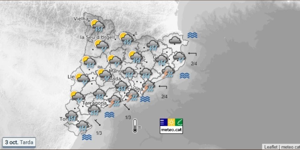
Catalonia has imposed sweeping restrictions on travel and outdoor activities as authorities prepare for an exceptional episode of torrential rain overnight and into Sunday.
The INUNCAT flood emergency plan has been raised to emergency phase, with people across 20 comarques told to avoid non-essential journeys from 8.00 pm on Saturday until 2.00 pm on Sunday. The most dangerous conditions are expected overnight and during Sunday morning.
The restrictions cover areas across Barcelona, Girona and Tarragona provinces. Catalan Civil Protection said the latest forecasts point to an exceptional situation because of both the intensity of the rainfall and the amount that could accumulate.
The measures will remain in force from 8.00 pm on Saturday until 2.00 pm on Sunday across 20 comarques.
Travel and outdoor activities restricted
Non-essential journeys are being restricted in the affected areas, while sporting, cultural and leisure activities are suspended. Markets, fairs and other outdoor public events are also affected, along with activities in parks, gardens and areas vulnerable to flooding.
Authorities have called for remote working wherever possible, while educational and university activities during the restriction period are also affected.
The 20 comarques covered by the restrictions are Alt Empordà, Baix Empordà, Alt Penedès, Baix Llobregat, Barcelonès, Garraf, Garrotxa, Gironès, Pla de l’Estany, Vallès Occidental, Vallès Oriental, Maresme, Selva, Alt Camp, Baix Camp, Baix Penedès, Osona, Ripollès, Tarragonès and Moianès.
More than 200mm of rain possible
AEMET issued an updated special weather warning at 2.32 pm on Saturday, saying conditions would deteriorate along the Barcelona coast during the final hours of the day, with rainfall potentially becoming locally torrential.
Sunday is expected to bring the greatest impact. AEMET says very heavy or torrential rain is forecast in Barcelona and Girona provinces, where accumulated rainfall could exceed 200mm in 12 hours. The agency is urging people to take extreme precautions.
Meteocat has placed parts of Catalonia under its highest level of danger for rainfall intensity. Its warning system shows the potential for more than 40mm in 30 minutes, highlighting how quickly conditions could deteriorate during the most intense storms.
Flash flooding is the main danger
The greatest concern is the possibility of intense rain falling over a very short period. That can overwhelm drainage systems and rapidly raise water levels in streams, rivers and other flood-prone areas.
AEMET has warned that the wider weather episode could produce sudden local flooding in low-lying areas, streams and ramblas. The danger is greater in places where substantial amounts of rain have already fallen during recent days.
The unstable weather is being driven by cold air at higher levels combined with a significant supply of Mediterranean moisture. A DANA is expected to become isolated to the west of the peninsula, allowing the unsettled conditions to continue until at least Sunday.
Barcelona, Girona and Tarragona affected
The threat is not confined to Barcelona. The restrictions stretch across areas of Tarragona, Barcelona and Girona provinces, with the focus of the heaviest rainfall expected to move as the weather system develops.
Barcelona itself is forecast to see rain through Saturday evening and into Sunday, while Girona is also preparing for increasingly severe conditions.
People elsewhere in Catalonia are being urged to remain alert even if their area is not among the 20 comarques covered by the restrictions, as thunderstorms can develop and move quickly.
Woman dies and 90 rescued as floods hit parts of Spain
Restrictions remain until Sunday afternoon
Residents and visitors in affected areas should avoid unnecessary journeys, stay away from rivers, streams, and flood-prone areas, and never attempt to cross a flooded road or watercourse.
The restrictions are currently due to remain in place until 2.00 pm on Sunday, 4 October, although authorities will continue to assess conditions as the storm develops.
With the most dangerous period expected overnight and during Sunday morning, anyone in the affected areas should follow Civil Protection, Meteocat, and local authority instructions and call 112 in an emergency.