 Lorraine Williamson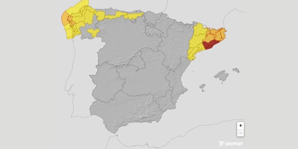
Torrential rain is causing widespread travel disruption in Catalonia on Tuesday morning, with Spain’s highest weather warning in force and high-speed and regional train services suspended.
Severe storms are hitting north-eastern Spain on Tuesday morning as AEMET’s red weather warning comes into force, bringing torrential rain and an increasing risk of flooding. The most serious warning covers northern coastal and pre-coastal Tarragona, where as much as 180mm could fall within three to six hours.
The weather has already caused significant disruption across Catalonia. High-speed and regional rail services have been suspended or interrupted, emergency alerts have been sent to residents, and authorities are warning people to avoid unnecessary travel and stay away from rivers and flood-prone areas.
Red alert as torrential rain moves across Catalonia
AEMET’s red warning, its highest alert level and classified as an “extraordinary danger”, is in force in northern coastal and pre-coastal Tarragona from 6.00 am until 2.59 pm on Tuesday. Up to 180 litres of rain per square metre could accumulate within three to six hours, creating a significant risk of flooding and sudden rises in rivers and other watercourses.
Orange warnings are also affecting Barcelona, Girona and other parts of Tarragona, with intense thunderstorms continuing across the region. AEMET has warned of very heavy showers and thunderstorms affecting both Tarragona and Barcelona.
Trains suspended as conditions deteriorate
The severe weather is having a significant impact on rail travel. Renfe has suspended a number of AVE, Avant, Euromed and Media Distancia services during Tuesday morning as a precaution because of the intensity of the rainfall.
Rodalies and Ferrocarrils de la Generalitat services have also experienced interruptions and delays, affecting commuters and other passengers across Catalonia. Road travel is proving difficult in places too, with drivers urged to exercise extreme caution where standing water or flooding is affecting routes.
Emergency alerts sent to residents
Civil Protection has sent emergency alerts to residents in several Catalan comarcas as authorities respond to the developing flood risk. The warnings include Alt Penedès, Anoia and Baix Llobregat, while water authorities are monitoring rising levels in rivers and other watercourses.
Residents in affected areas have been advised to limit journeys, avoid crossing flooded roads and stay away from riverbeds, streams and other locations vulnerable to flash flooding. Intense rainfall over a short period can cause water levels to rise extremely quickly.
Severe weather extends beyond Catalonia
Although Catalonia is facing Spain’s most serious weather warning on Tuesday morning, the unsettled conditions extend across several other parts of the country. Seven autonomous communities have warnings in force, with orange alerts also affecting parts of the Valencia region and Galicia.
Castellón and Valencia face warnings for heavy rain, while A Coruña is under an orange coastal warning. Warnings for rain and thunderstorms also affect parts of Aragón, Castilla-La Mancha and Navarra, with strong winds, hail and locally intense downpours possible as the unstable weather moves across the country.
Valencia remains on alert
Emergency authorities in the Valencia region have also activated flood precautions, with orange-level rain warnings affecting northern inland Valencia and southern inland Castellón.
The regional emergency coordination centre has activated a hydrological pre-emergency for the River Magro basin and called on municipalities in the area to step up monitoring of locations known to be vulnerable to flooding.
When will conditions improve?
The highest-level Tarragona warning is currently scheduled to remain in force until 2.59 pm on Tuesday. Conditions are expected to evolve during the day, although heavy showers and thunderstorms remain possible elsewhere in Catalonia.
AEMET’s forecast indicates that instability should gradually ease later, but locally strong storms remain possible. Anyone travelling in affected areas should check current weather warnings and transport information before setting out, as rail services and road conditions may change quickly during the day.