 Lorraine Williamson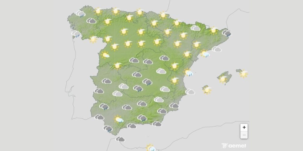
Heavy rain, thunderstorms, hail, and strong wind gusts are forecast across large parts of Spain on Monday, with 12 autonomous communities under weather warnings and Catalonia facing the highest risk.
Spain is facing a sharp change in the weather on Monday, 28 September, with warnings for rain and thunderstorms stretching across much of the country after an exceptionally warm spell.
The most serious conditions are expected in Catalonia, where AEMET has issued orange warnings for parts of Barcelona and Tarragona. Some areas could receive 40mm of rain in just one hour, with forecasters warning that more than 100mm could fall within only two or three hours in the most intense downpours.
Catalonia faces heaviest rainfall
Orange warnings, indicating an important meteorological risk, are due to come into force at 9.00 pm in parts of Catalonia. The Pre-Pyrenees, coast, and pre-coastal areas of Barcelona could receive up to 40mm in an hour, while Barcelona’s central depression could see around 30mm. Parts of Tarragona are also under orange warnings. AEMET forecasts up to 40mm in one hour and 100mm over 12 hours along northern and southern coastal and pre-coastal areas.
Forecasters have cautioned that the rainfall may be particularly concentrated, meaning totals exceeding 100mm in just two or three hours cannot be ruled out.
Lleida is under yellow warnings, where thunderstorms could also produce hail and wind gusts of between 70 and 90km/h.
Storm warnings stretch across Spain
Catalonia is not the only part of the country affected. Yellow warnings have been issued across a broad swathe of Spain as unstable conditions spread during Monday afternoon and evening.
In Aragón, areas of Teruel, Zaragoza, and Huesca face rain and thunderstorms, with some locations potentially recording 20mm in an hour or 40mm over 12 hours. Hail and gusts reaching between 70 and 90km/h are also possible.
Warnings are in force in parts of Asturias, Cantabria, Galicia, Navarra, and the Basque Country, where locally heavy showers may be accompanied by thunderstorms and hail.
Castilla y León is also affected, including areas of Ávila, Salamanca, Zamora, and Burgos. AEMET warns that some storms could bring very strong gusts as well as hail.
Rain and thunderstorms across southern Spain
Further south, Andalucía has yellow warnings covering parts of Cádiz, Málaga, and Huelva.
Grazalema and the Strait of Gibraltar are among the areas affected in Cádiz, while warnings in Málaga include Antequera, Ronda, the Costa del Sol, and Guadalhorce, and Axarquía. Rainfall could reach 15mm in an hour, accompanied by occasional thunderstorms.
Aracena in Huelva is also under a yellow warning for rain and thunderstorms, with hail possible.
Extremadura has warnings across parts of Badajoz and Cáceres, while Ceuta is also expecting heavy showers and thunderstorms.
Valencia and Castilla-La Mancha also affected
The change in weather extends into eastern and central Spain.
Yellow warnings cover the southern interior of Castellón and northern and southern inland Valencia, where rainfall could reach 20mm in an hour and thunderstorms are forecast.
In Castilla-La Mancha, the Serranía de Cuenca is under warnings for rain and storms. Around 15mm could fall in an hour, with accumulations potentially reaching 40mm over 12 hours.
Temperatures fall after late September heat
The storms accompany a marked change in temperatures following an unusually hot end to September.
AEMET spokesman Rubén del Campo said instability would increase during the week, bringing locally heavy rain and showers to extensive areas of mainland Spain. Temperatures are also expected to fall sharply in some areas as the weather pattern changes.
The unsettled conditions are not expected to disappear immediately, with further showers and thunderstorms possible as the week progresses.
When will the worst weather arrive?
For many areas, the main period to watch will be Monday afternoon and evening.
Most warnings intensify later in the day, while Catalonia’s orange warnings are scheduled to begin at 21:00 and remain in force until the end of Monday.
Anyone in affected areas should check the latest AEMET warnings before travelling, particularly where thunderstorms, intense rainfall, hail, or strong wind gusts are forecast. Warning levels and affected areas can change as conditions develop.