 Lorraine Williamson
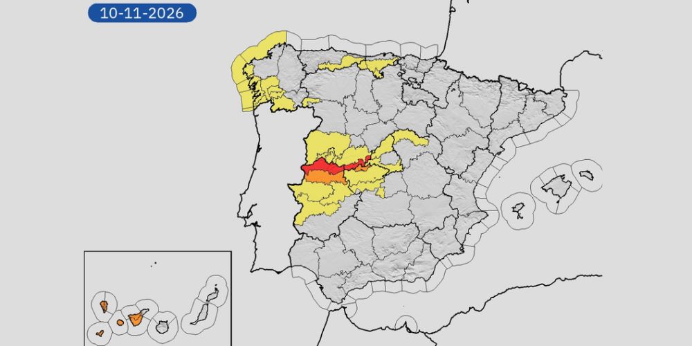
Spain is facing several more days of severe weather as Storm Charles approaches while Storm Bruna continues to bring heavy rainfall and strong winds across the country. Authorities warn that Wednesday 11 November could be the most dangerous day, with exceptional rainfall, flooding, and wind gusts potentially exceeding 130km/h in exposed parts of the Canary Islands.
Spain’s Civil Protection authorities issued a renewed warning on Monday 9 November, highlighting the combined impact of two high-impact storms. The approaching system, Charles, is expected to intensify an already unsettled period of weather, particularly across southern and western Spain.
According to the official Civil Protection statement, some areas could receive more than 300 litres of rain per square metre over the entire episode, raising concerns about flash flooding, swollen rivers and landslides.
Wednesday expected to bring the worst conditions
Storm Charles, a weather system of subtropical origin, is expected to approach the Iberian Peninsula through Portugal on Wednesday 11 November. Its arrival will coincide with the continuing effects of Storm Bruna, bringing another period of widespread rain, thunderstorms and damaging winds.
The heaviest rainfall is expected across western, southern and central Spain, particularly in mountainous areas where rising air can intensify precipitation. Parts of the western Central System could receive more than 150 litres per square metre on Wednesday alone.
The situation is especially concerning because the ground in some areas will already have absorbed substantial rainfall earlier in the week. Rivers and streams could rise rapidly, while slopes affected by summer wildfires may be particularly vulnerable to erosion and landslides.
Andalucia faces heavy rain and damaging winds
Andalucia is among the regions expected to experience some of the strongest effects of Storm Charles, particularly on Wednesday.
Forecasters say rainfall could approach 100 litres per square metre during the day in parts of the Sierra de Aracena, Sierra de Grazalema, Serranía de Ronda, Sierra Nevada and Málaga province.
The Costa del Sol, particularly areas closer to the Strait of Gibraltar, could also experience intense rainfall. AEMET’s Andalucia representative, Juan de Dios del Pino, has warned that Wednesday is likely to bring the most significant deterioration in conditions across the region.
Winds could become particularly dangerous from midday, with gusts reaching 90–100km/h in parts of Andalucia, Extremadura and western Castilla-La Mancha. Unlike many mountain wind events, these speeds could also occur at lower elevations, including areas near the Andalucian coastline.
The Gulf of Cádiz is expected to experience increasingly rough seas, with waves potentially reaching five metres by Wednesday evening.
Canary Islands could see gusts above 130km/h
The Canary Islands are expected to feel the effects of Storm Charles from late Tuesday, ahead of the most intense conditions on Wednesday.
Wind gusts of 80–100km/h are forecast in exposed and elevated areas, with the possibility of speeds exceeding 130km/h in parts of La Palma and Tenerife.
Heavy showers and thunderstorms are also expected, particularly on La Palma, where rainfall could become locally very intense. Other islands may experience strong downpours, especially on their southern and western slopes.
The combination of powerful winds, heavy rain and dangerous seas could disrupt outdoor activities, road travel and maritime operations. Residents and visitors are being advised to monitor local emergency announcements.
Red weather warnings issued for Tuesday
Before Charles arrives, Storm Bruna is expected to continue bringing significant rainfall to western Spain. AEMET has issued red weather warnings for Tuesday 10 November in northern Cáceres and southern Ávila, where rainfall could reach 120 litres per square metre within 12 hours.
These warnings indicate an extraordinary level of danger, particularly where rivers, streams and drainage systems may struggle to cope with the volume of water.
Galicia, western Castilla y León and Extremadura are also expected to experience substantial rainfall. Strong winds will continue across mountainous areas, while Atlantic coastal conditions remain hazardous.
What residents and visitors should do
Spain’s emergency authorities are urging the public to take precautions during the storm.
People living in flood-prone areas should keep an eye on local warnings and avoid travelling unnecessarily when severe weather is forecast. Drivers should never attempt to cross flooded roads, even when the water appears shallow.
Loose objects on balconies and terraces should be secured, particularly in areas expecting powerful wind gusts. Coastal visitors should stay away from exposed promenades, harbour walls and beaches during dangerous sea conditions.
Anyone planning to travel should check road conditions and transport updates before leaving. The latest weather warnings are available through AEMET’s official alert service. Meanwhile, road incidents and restrictions can be checked through the DGT traffic information service.
In an emergency anywhere in Spain, call 112.
When will the storms ease?
Current forecasts suggest conditions should begin improving from Thursday 12 November as Storm Charles moves northeast.
Rainfall is expected to become less widespread, although some northern areas could continue experiencing heavy showers. Strong winds may also persist across central and eastern Spain as the system moves away.
There is still uncertainty surrounding the precise path of Storm Charles, and even a relatively small change could alter which areas experience the heaviest rain and strongest winds.
With two powerful storms affecting Spain in quick succession, residents are advised to follow updated official forecasts rather than relying on earlier predictions. Wednesday remains the main day of concern, particularly across Andalucia, western Spain and the Canary Islands.