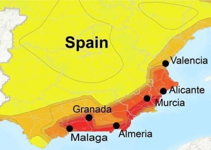
MADRID – Earthquakes regularly occur in numerous areas in Spain. However, it is a very natural phenomenon. And most are not felt by anyone. Furthermore, only some people above the epicentre perceive a vibration, and only at the heaviest should anyone become alarmed.
Especially in places above fault lines, there are episodes of earthquakes. To see the areas in Spain most often subject to earthquakes, view this map from the Spanish National Geographic Institute. At the time of writing, the last quake occurred at 10.05 am on Tuesday in the Gulf of Valencia. It had the power of 1.5 on the Richter scale.
Collapse map
University of Alicante (UA) researchers have created a map showing the probability of reinforced concrete buildings collapsing after an earthquake. The study shows risk depends on design acceleration indicated in the regulations regarding earthquake resistance and the seismic hazard curve.
Seismic acceleration is the measure of an earthquake most commonly used in construction engineering. It is also the value used to determine seismic prescriptions and seismic risk zones. During an earthquake, damage to buildings and infrastructure is closely related to speed and seismic acceleration. And not to the magnitude or strength of the earthquake. Seismic acceleration consists of a direct measurement of the accelerations experienced by the ground surface.
The new map of the zones with the highest risk of collapse is part of the final results of the ‘RETOS2016 Project: Ground Motion Scenarios Focusing on Seismic Risk’. Application to Damage, Loss and Contingency Scenarios (CGL2016-77688-R)’.
Probability of collapse analysis
Researchers Alireza Kharazian, Sergio Molina, Juan J.Galiana, and Noelia Agea of the Multidisciplinary Institute for the Study of the Environment (IMEM) have obtained an updated map of seismic hazard in Spain in the first place. Based on this information and taking into account the vulnerability of the buildings, they analysed the probability of collapse.
This information together is now presented in the form of a risk coefficient map. These and the results of the study were recently published in the article ‘Risk-targeted hazard maps for Spain’ in the scientific journal ‘Bulletin of Earthquake Engineering’.
The scientists determine that the probability of collapse depends not only on the design acceleration value, which is currently indicated in the earthquake-resistant regulations but also on the shape of the seismic hazard curve.
After analysing the cities with the highest seismic hazard in the country, which are therefore most likely to experience earthquakes, the researchers noted that design acceleration should be increased in all cities to reduce the likelihood of building collapse.
Risk for zones in Murcia and Alicante
The biggest increase is needed in Murcia, followed by Alicante. This may also explain the significant damage that occurred after the major earthquake in Lorca (Murcia) in 2011, the researchers conclude. They received funding and support from the municipalities of Alicante and Elche.


