")
MADRID – While an earlier DANA loses momentum in eastern Spain, a new one is on its way. This one will cross the Iberian Peninsula from France westwards.
That also means it will rain in parts of Spain where it has rarely done so far. Furthermore, the weather remains unstable and turbulent today, Thursday, May 25 due to the remnants of the Mediterranean DANA weakening. The approaching DANA adds to that. Weather services warn of thunderstorms and intense rainfall in various parts of the peninsula. This mainly concerns the east, the Balearic Islands and parts of the Cantabrian region. There are yellow warnings in effect.
New DANA active in Spain from Thursday night
The new DANA is currently over the southern part of France and will encounter an already unstable and humid environment caused by the previous, already weakened DANA. It has already set historic rainfall records in several parts of southern and eastern Spain in recent days. Then, there was abundant rainfall, hailstorms and local flooding.
Heavy showers and possible flooding in the Madrid region
Images show intense thunderstorms and showers currently developing over the northeast of the peninsula and other parts of the east. Although precipitation will be less intense than earlier this week in parts of eastern Spain, there may still be sustained and intense rainfall. However, heavy showers and floods are predicted for the Madrid region by Eltiempo.es. These mainly take place in the night from Thursday to Friday.
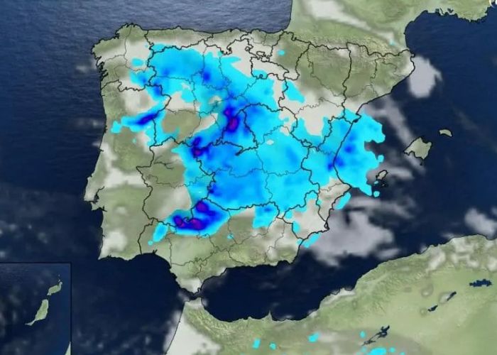
Precipitation amounts
The expected precipitation amounts are between 10-30 mm in flat areas. In particular, the Central system and the southern slopes can receive significant amounts of up to 50-70 mm between Thursday and Friday. Once the DANA moves into the Atlantic Ocean, low pressure areas and troughs will continue to provide unstable and cool weather. As a result, more precipitation is expected for the coming weekend and the beginning of next week.

Orange warning
The Spanish weather service Aemet is issuing an orange warning for precipitation and thunderstorms for Thursday for the northern and southern coastal zone of the province of Castellón, the northern part of the province of Valencia, both coastal and inland.
What is a DANA?
DANA stands for Depresión Aislada en Niveles Altos, which translates to “Isolated High-Level Depression” in English. It is a meteorological phenomenon that commonly occurs in the Mediterranean region, including Spain. Furthermore, it is characterised by the formation of a low-pressure system at high altitudes, typically in the upper levels of the atmosphere.
DANAs are often associated with unstable weather conditions, including heavy rain, thunderstorms, and sometimes even severe weather events such as hailstorms and flash floods. They can bring prolonged periods of precipitation to affected areas, leading to significant rainfall accumulations over a relatively short period.
DANAs are known for their relatively small size and isolated nature, meaning they can form and move independently from larger weather systems. They are typically associated with slow-moving or stationary weather patterns, which can result in an extended duration of rainfall over a specific area.