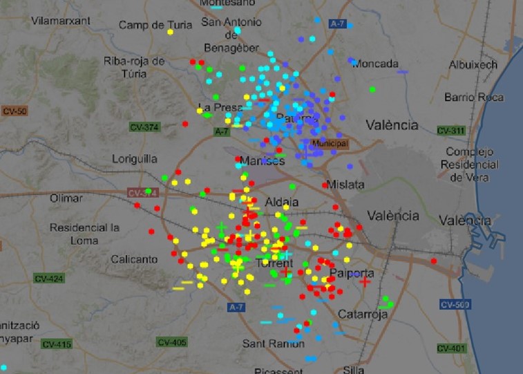
VALENCIA – On Saturday morning, the western part of the metropolitan area of Valencia – where Manises airport is located – was confronted with a very violent hail storm with very strong wind gusts and visibility of 800 metres.
This was announced by the regional branch of the State Meteorological Agency Aemet. The storm mainly hit the western part of the metropolis of Valencia from 6.10 am with hail from 7 am, so a total of 90.4 litres per square metre has accumulated, with wind gusts of 78 kilometres per hour.
Related post: DANA brings floods in Valencia and Alicante on Friday
This version of the DANA has already left a rainfall of 202.8 l/m2 in the month of November at Valencia airport, of which 148.7 l/m2 in the last 36 hours. A few kilometres away, in the centre of the city, the amount collected in the same period barely exceeds one litre per square metere. See a picture of the distribution of lightning during the thunderstorms here on Twitter.
High risk of flooding
According to Aemet’s data record, this downpour is the third most intense downpour at Valencia airport in the month of November and the third highest in the series since 1980. It was surpassed only by the 91.8 litres recorded on July 15. 1990 and 101.9 litres on September 28, 2012.
According to Stormalert, the risk of flooding is high because the showers that hang over the provinces of Valencia and Castellón are slow-moving and heavy. Meteored said on Twitter the storms “are practically static”:
¡Espectacular! Las tormentas ⛈️ han "saltado" en el este peninsular en zonas de convergencia de vientos, y además están prácticamente estáticas.
En puntos de la Comunidad Valenciana superan los 100 l/m2 hoy. Además, con pedrisco 🧊. pic.twitter.com/2NLoLEwXXi
— Meteored | tiempo.com (@MeteoredES) November 12, 2022
All precipitation records of November were broken
In this episode, all records for rainfall in the month of November were broken at the airport. First, the record for the most intense shower (66.1 in one hour). Second, the day with the most precipitation (148.7). Third, the month of November with the most rain in one hour. most accumulated precipitation (202.8, provisional).
Forecast for Saturday
The rain and wind storm affecting much of the region will remain active in the northern half this Saturday. Later in the day these will ease, according to Aemet’s forecast. Cloudy periods are expected in the southern half, with mists and morning fog banks inland.
Weather forecast for Sunday
Tomorrow, Sunday, there may still be a few isolated showers, and the occasional storm on the coast. However, Aemet expects an increase in maximum temperatures as southerly winds on the coast and westerly winds inland.
Incidents due to the heavy weather
Aldaida is one of the places most affected by the waterspout. The valley is flooded, and cars in flooded streets were swept away by the water. Click here for images.
New records of amounts of rain on Saturday: Vallibona 61.2 La Pobla de Vallbona 51.2 L’Eliana 43.8 Culla 38.41
The rain and hail storm has resulted in two of the main roads to and from l’Eliana being closed. The waterspout also caused a traffic jam in the underpass to the metro tracks on the road connecting the municipality with Riba-roja de Turia.
Más imágenes de los cuantiosos daños que ha provocado la #tormenta esta mañana.
📍Desde Riba-roja de Túria (#Valencia). @ayto_riba_roja pic.twitter.com/yT2A9DkKcs
— SomosMéteo (@SomosMeteo) November 12, 2022
Along with the thunderstorm, there was also a hailstorm in areas such as Camp de Túria. Here, hailstones covered some of the ground. According to the Provincial Consortium of Castellón, the fire brigade on the north coast had to turn out almost 20 times because of rain incidents. Several people trapped in their cars by the water have been rescued. The boulevard of Alboraya was completely flooded this morning.


